on this page
-
Markets
-
Services
-
Location
England, Wales and Northern Ireland
-
Client
Geospatial Commission
-
Collaborators
Ordnance Survey, 1Spatial, GeoPlace, The Greater London Authority
-
Completion date
Ongoing

Guy Ledger
Divisional Digital Director, contact form
Developing a bespoke digital solution to securely map the UK’s underground assets.
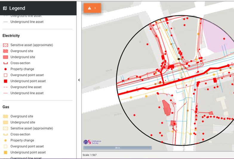
Pretty much every construction project starts with a hole in the ground. But before you start digging, you need to know what is buried there.
There are estimated to be 4 million kilometres of buried pipes and cables in the UK, including telecoms and internet, gas, water, and electricity. Up until now, there has been no centralized database to show you where all these underground obstructions are, forcing anyone who wishes to safely dig to seek records from every possible asset owner in the area.
Every year there are estimated to be 60,000 utility strikes, where construction and maintenance workers accidently damage underground assets. This is a huge problem: endangering the lives of those digging, delaying construction; disrupting traffic; and causing interruption to essential services such as power, water, gas and telecoms. In fact, the economic cost to the UK of the disruption caused by utility strikes is estimated to be £2.4bn a year.
Please note that you are now leaving the AtkinsRéalis website (legal name: AtkinsRéalis Group inc.) and entering a website maintained by a third party (the "External Website") and that you do so at your own risk.
AtkinsRéalis has no control over the External Website, any data or other content contained therein or any additional linked websites. The link to the External Website is provided for convenience purposes only. By clicking "Accept" you acknowledge and agree that AtkinsRéalis is not responsible, and does not accept or assume any responsibility or liability whatsoever for the data protection policy, the content, the data or the technical operation of the External Website and/or any linked websites and that AtkinsRéalis is not liable for the terms and conditions (or terms of use) of the External Website. Further, you acknowledge and agree that you assume all risks resulting from entering and/or using the External Website and/or any linked websites.
BY ENTERING THE EXTERNAL WEBSITE, YOU ALSO ACKNOWLEDGE AND AGREE THAT YOU COMPLETELY AND IRREVOCABLY WAIVE ANY AND ALL RIGHTS AND CLAIMS AGAINST ATKINSRÉALIS, AND RELEASE, DISCHARGE, INDEMNIFY AND HOLD HARMLESS ATKINSRÉALIS, ITS OFFICERS, EMPLOYEES, DIRECTORS AND AGENTS FROM ANY AND ALL LIABILITY INCLUDING BUT NOT LIMITED TO LIABILITY FOR LOSS, DAMAGES, EXPENSES AND COSTS ARISING OUT OF OR IN CONNECTION WITH ENTERING AND/OR USING THE EXTERNAL WEBSITE AND/OR ANY LINKED WEBSITES AND ANY DATA AND/OR CONTENT CONTAINED THEREIN.
Such waiver and release specifically includes, without limitation, any and all rights and claims pertaining to reliance on the data or content of the External Website, or claims pertaining to the processing of personal data, including but not limited to any rights under any applicable data protection statute. You also recognize by clicking “Accept” that the terms of this disclaimer are reasonable.
The information provided by Virtua Research cited herein is provided “as is” and “as available” without warranty of any kind. Use of any Virtua Research data is at a user’s own risk and Virtua Research disclaims any liability for use of the Virtua Research data. Although the information is obtained or compiled from reliable sources Virtua Research neither can nor does guarantee or make any representation or warranty, either express or implied, as to the accuracy, validity, sequence, timeliness, completeness or continued availability of any information or data, including third-party content, made available herein. In no event shall Virtua Research be liable for any decision made or action or inaction taken in reliance on any information or data, including third-party content. Virtua Research further explicitly disclaims, to the fullest extent permitted by applicable law, any warranty of any kind, whether express or implied, including warranties of merchantability, fitness for a particular purpose and non-infringement.
The consensus estimate provided by Virtua Research is based on estimates, forecasts and predictions made by third party financial analysts, as described above. It is not prepared based on information provided by AtkinsRéalis and can only be seen as a consensus view on AtkinsRéalis' possible future results from an outside perspective. AtkinsRéalis has not provided input on these forecasts, except by referring to past publicly disclosed information. AtkinsRéalis does not accept any responsibility for the quality or accuracy of any individual or average of forecasts or estimates. This web page contains forward-looking statements based on current assumptions and forecasts made by third parties. Various known and unknown risks, uncertainties and other factors could lead to material differences between AtkinsRéalis' actual future results, financial situation, development or performance, and the estimates given here.
We are delighted with the news that the MVP is now expanding across the country sooner than planned, marking a significant step towards a smarter and more resilient future.
Heidi Mottram
Chief Executive, Northumbrian Water
A window to the world beneath our feet
The National Underground Asset Register (NUAR) has been created to help with the challenges surrounding data sharing, by aggregating England, Wales and Northern Ireland’s underground assets into a single centralized database (Scotland manages their data separately). AtkinsRéalis has been the delivery partner for the build phase of this project following a discovery phase in which the project’s feasibility and economic case were explored and established.
This complex project had three main challenges: to engage with and collect data from over 700 asset owners; to transform and ingest this data into a single comprehensive database; and to develop a secure portal through which users can view and access this information.
With any project of this scale and ambition, some degree of industry scepticism about our ability to deliver was likely. Consequently, we were expecting to see some reluctance to share data. However, NUAR was predicted to reduce the costs of data-sharing by an estimated £91m a year, by reducing the amount of time and resources asset owners and other stakeholders would have to spend making and answering queries. Understanding of this benefit, but also the safety benefits to workers of having all the information instantly and easily available in one place, resulted in great take-up from utility providers - particularly the major ones in the energy, water and telecommunications sectors. This allowed us to launch NUAR across England and Wales. As more asset owners are onboarded, we have also seen a snowball effect, with the value to asset owners of sharing data with NUAR increasing with each provider we have signed up.
From the project onset the system has been developed collaboratively with users. This is an ongoing process, with the team using a combination of user conversations, testing, and focus groups to help develop the bespoke solution. This allows users to securely and efficiently access this critical infrastructure data. Particular focus has gone into making the map mobile friendly, as feedback indicates this will be a significant proportion of the user base.
The continued updating of the NUAR platform and expansion of the MVP area gives asset owners the confidence that those enquiring about asset locations will have the available tools at their fingertips to plan accordingly.
Colin Sawkins
Assurance and Enabling Specialist, Cadent Gas
A standard format for underground asset data
When we began working on NUAR, there was no standard format for sharing underground asset information in England, Wales and Northern Ireland. As a result, asset owners currently hold their records in a wide variety of different formats, from custom-built databases to non-vectorized PDF files. This posed a significant technical challenge when importing this data.
To build a single harmonized map of underground assets, all data has been converted into a common standard format. This had to be done on a massive scale, with data coming from hundreds of asset owning organizations, and it also had to be easily repeatable, so that when asset owners updated their records these changes could flow through to the NUAR platform. This required efficient and sustainable methods of data transformation.
We brought data transformation specialists 1Spatial into the team to help address this challenge – developing and adapting a range of tools to manage this data transformation and minimize the need for human intervention. We also created an API (or Application Programming Interface) which is being tested by a small subset of early adopter asset owners to enable a more automated way of providing data to NUAR.
Please note that you are now leaving the AtkinsRéalis website (legal name: AtkinsRéalis Group inc.) and entering a website maintained by a third party (the "External Website") and that you do so at your own risk.
AtkinsRéalis has no control over the External Website, any data or other content contained therein or any additional linked websites. The link to the External Website is provided for convenience purposes only. By clicking "Accept" you acknowledge and agree that AtkinsRéalis is not responsible, and does not accept or assume any responsibility or liability whatsoever for the data protection policy, the content, the data or the technical operation of the External Website and/or any linked websites and that AtkinsRéalis is not liable for the terms and conditions (or terms of use) of the External Website. Further, you acknowledge and agree that you assume all risks resulting from entering and/or using the External Website and/or any linked websites.
BY ENTERING THE EXTERNAL WEBSITE, YOU ALSO ACKNOWLEDGE AND AGREE THAT YOU COMPLETELY AND IRREVOCABLY WAIVE ANY AND ALL RIGHTS AND CLAIMS AGAINST ATKINSRÉALIS, AND RELEASE, DISCHARGE, INDEMNIFY AND HOLD HARMLESS ATKINSRÉALIS, ITS OFFICERS, EMPLOYEES, DIRECTORS AND AGENTS FROM ANY AND ALL LIABILITY INCLUDING BUT NOT LIMITED TO LIABILITY FOR LOSS, DAMAGES, EXPENSES AND COSTS ARISING OUT OF OR IN CONNECTION WITH ENTERING AND/OR USING THE EXTERNAL WEBSITE AND/OR ANY LINKED WEBSITES AND ANY DATA AND/OR CONTENT CONTAINED THEREIN.
Such waiver and release specifically includes, without limitation, any and all rights and claims pertaining to reliance on the data or content of the External Website, or claims pertaining to the processing of personal data, including but not limited to any rights under any applicable data protection statute. You also recognize by clicking “Accept” that the terms of this disclaimer are reasonable.
The information provided by Virtua Research cited herein is provided “as is” and “as available” without warranty of any kind. Use of any Virtua Research data is at a user’s own risk and Virtua Research disclaims any liability for use of the Virtua Research data. Although the information is obtained or compiled from reliable sources Virtua Research neither can nor does guarantee or make any representation or warranty, either express or implied, as to the accuracy, validity, sequence, timeliness, completeness or continued availability of any information or data, including third-party content, made available herein. In no event shall Virtua Research be liable for any decision made or action or inaction taken in reliance on any information or data, including third-party content. Virtua Research further explicitly disclaims, to the fullest extent permitted by applicable law, any warranty of any kind, whether express or implied, including warranties of merchantability, fitness for a particular purpose and non-infringement.
The consensus estimate provided by Virtua Research is based on estimates, forecasts and predictions made by third party financial analysts, as described above. It is not prepared based on information provided by AtkinsRéalis and can only be seen as a consensus view on AtkinsRéalis' possible future results from an outside perspective. AtkinsRéalis has not provided input on these forecasts, except by referring to past publicly disclosed information. AtkinsRéalis does not accept any responsibility for the quality or accuracy of any individual or average of forecasts or estimates. This web page contains forward-looking statements based on current assumptions and forecasts made by third parties. Various known and unknown risks, uncertainties and other factors could lead to material differences between AtkinsRéalis' actual future results, financial situation, development or performance, and the estimates given here.
Delivering the National Underground Asset Register
NUAR is currently operating as an MVP at the Ordnance Survey and covers all of England, Wales and Northern Ireland. Plans are in place to progress to Public Beta in the coming months, enabling asset owners to use NUAR as the sole source of asset data (subject to internal risk assessment).
The project has already seen significant traction, with the platform already including data from over 170 asset owners, including all of the major energy and water providers.
To deliver the project the OneTeam approach was adopted, bringing about the positive team culture required for such a huge challenge. With this way of working, all organisations working on the contract operated together, rapidly addressing barriers as they emerged. We were mission focused with members of each project workstream knowing and empowered to reach their goals. Through respectful challenge we were able to pivot our approach and use novel methods, for example, in engaging and acquiring data from asset owners.
Overall, NUAR is forecast to save the UK an estimated £490m per year, an impressive 36x return on investment. This will be seen through increased efficiency, reduced asset strikes (when underground pipes and cables are accidentally damaged) and reduced disruptions for the public and businesses. It is also hoped that the project will have a positive impact on carbon emissions, though this has not been tested or quantified at this time. Increasing data maturity is also a side benefit as many organisations adopt and/or enhance their data systems and standards.
Most importantly, by providing a reliable map of the world beneath our feet, NUAR will make construction projects safer and reduce the number of injuries and near misses on worksites across England, Wales and Northern Ireland.
We are delighted with the news that the MVP is being rolled out and expanded across England, Wales and Northern Ireland, marking a significant contribution towards a standard and consistent process for sharing of safe digging data.
Nigel Myers
Senior Statutory and Streetworks Manager, Virgin Media O2
Downloads
Trade releases