on this page
-
Markets
-
Services

Zoe Metcalfe
Client Director - Local and Central Government, United Kingdom contact form
By Zoe Metcalfe, Client Director - Local and Central Government UK
Nature is the world’s ultimate multi-tasker.
Planting trees upstream not only reduces downstream flood risk – it improves air quality, reduces the impact of extreme weather events, locks up carbon, protects the soil and can even improve mental and physical health outcomes in nearby communities. The reverse is also true, and depleted or otherwise vulnerable natural environments can often amplify shocks and stresses, from increased flood risk to heat islands and loss of keystone species.
In this incredibly interconnected system, a single intervention can make a big difference. But how can we assess this if we are not appropriately measuring our impact on the natural world, and vice versa?
In a traditional cost benefit analysis, the benefits provided by nature are not normally valued. We take them for granted because they are provided for free. But if we don’t measure this value, how can we make rational decisions? Or in the words of economist Joseph Stiglitz, “If you have the wrong metrics, you do the wrong things.”
To address this disconnection, we must develop an ecosystem valuation approach that does not ignore the natural environment but instead helps us better plan, predict, and model our effect on the planet’s diminishing reserves of natural capital in hand with human capital.
At AtkinsRéalis, we have been generating a solution that weaves together assessments of natural, human, and social capital with Geographic Information Systems (GIS) and Digital Twin technologies. This effectively creates dynamic ‘digital story books’ that can meaningfully visualise these complex data sets, and help planners, engineers and investors make decisions that will promote community and regional resilience.
These digital story books also enable us to take an asset-based community development methodology and approach, weaving in their needs and requirements as part of an evidence-based, co-development process. This empowers communities to share and build their social capital to be change-makers and be receptive to proposed interventions.
Capitalising on nature
Natural Capital Assessments assess natural capital stocks (habitats) and maps the benefit flows (or ecosystem services) from these stocks to humans. These assessments map both physical and monetary benefits, alongside articulating financial risk, allowing us to understand the impact of our natural stocks and to make more informed decisions.
We can use this insight to embed the real value of natural capital through biodiversity net gain (BNG), carbon codes and nutrient neutrality among others, to inform and support business cases, generate valuations for grant applications, statutory compliance and to develop the necessary depth of analysis for site interventions.
But how do we apply this information?
Advancements in Geographic Information Systems (GIS) and Digital Twin technologies have created a significant opportunity for the translation of remote sensing and other geospatial data sets into meaningful content. The resulting digital storybooks allow different stakeholders to assess potential interventions and explore ways to maximise the real value and long-term resilience of assets and communities.
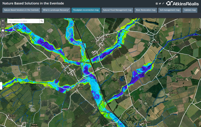
Building climate resilience on the Evenlode
One place where this technique has already delivered results is along the River Evenlode in Oxfordshire, where we worked in partnership with the Environment Agency, Natural England, the Evenlode Catchment Partnership and the North East Cotswolds Farmer Cluster.
Here, we used remotely sensed data from satellites to identify the best places to reconnect the river with its floodplain, creating new habitats along the river whilst protecting both the railway and downstream communities at risk from flooding. This was presented in an interactive digital storybook for landowners and stakeholders to explore. Two pilot schemes have already been delivered on Pudlicote Farm and on the Blenheim Estate where historic drainage has been reversed to restore ancient channels that can hold water in the landscape and boost biodiversity.
Visualising the data in this way is vital to kick-start wider landscape transformation. It allows us to identify the best places to reconnect the river with the land around it to regenerate wetland and farmland, and provide new inspiring vistas along public footpaths. Even more importantly, it also allows us to bring local communities and landowners on the journey with us – working together with a collective of local farmers to develop the digital storybook and to analyse how this new use of their land would benefit them and their local community.
Reconnecting the River Thames with its floodplain
Similar work on the River Thames was also made possible by deployment of a digital twin of the river and floodplain. It could be used to model the hydrological effects and ecosystem service benefits of different ideas generated by project partners during a formal co-creation and collaboration process.
Biodiversity is essential for ecosystem health and resilience, providing direct benefits to humans through genetic diversity, pest control, pollination, and a variety of other ecosystem services. However, river barriers on the Thames in this part of Oxfordshire (around an area known as Chimney Meadows owned and managed by the Berkshire, Buckinghamshire and Oxfordshire Wildlife Trust) were preventing the passage of fish upstream, reducing biodiversity and ecosystem resilience to climate change.
To repair this damage, and to re-enliven the surrounding meadows for both humans and nature, a 450m nature-based fish pass was built around one of the largest structures on the river. This not only opened up a 30km stretch of the Thames for fish spawning and migration for the first time in more than a century but reinvigorated the entire ecosystem, increasing health and wellbeing, providing new locations for recreation and learning, and improving the area’s ability to store floodwaters and carbon.
This article was originally published in New Civil Engineer in December 2023.
Please note that you are now leaving the AtkinsRéalis website (legal name: AtkinsRéalis Group inc.) and entering a website maintained by a third party (the "External Website") and that you do so at your own risk.
AtkinsRéalis has no control over the External Website, any data or other content contained therein or any additional linked websites. The link to the External Website is provided for convenience purposes only. By clicking "Accept" you acknowledge and agree that AtkinsRéalis is not responsible, and does not accept or assume any responsibility or liability whatsoever for the data protection policy, the content, the data or the technical operation of the External Website and/or any linked websites and that AtkinsRéalis is not liable for the terms and conditions (or terms of use) of the External Website. Further, you acknowledge and agree that you assume all risks resulting from entering and/or using the External Website and/or any linked websites.
BY ENTERING THE EXTERNAL WEBSITE, YOU ALSO ACKNOWLEDGE AND AGREE THAT YOU COMPLETELY AND IRREVOCABLY WAIVE ANY AND ALL RIGHTS AND CLAIMS AGAINST ATKINSRÉALIS, AND RELEASE, DISCHARGE, INDEMNIFY AND HOLD HARMLESS ATKINSRÉALIS, ITS OFFICERS, EMPLOYEES, DIRECTORS AND AGENTS FROM ANY AND ALL LIABILITY INCLUDING BUT NOT LIMITED TO LIABILITY FOR LOSS, DAMAGES, EXPENSES AND COSTS ARISING OUT OF OR IN CONNECTION WITH ENTERING AND/OR USING THE EXTERNAL WEBSITE AND/OR ANY LINKED WEBSITES AND ANY DATA AND/OR CONTENT CONTAINED THEREIN.
Such waiver and release specifically includes, without limitation, any and all rights and claims pertaining to reliance on the data or content of the External Website, or claims pertaining to the processing of personal data, including but not limited to any rights under any applicable data protection statute. You also recognize by clicking “Accept” that the terms of this disclaimer are reasonable.
The information provided by Virtua Research cited herein is provided “as is” and “as available” without warranty of any kind. Use of any Virtua Research data is at a user’s own risk and Virtua Research disclaims any liability for use of the Virtua Research data. Although the information is obtained or compiled from reliable sources Virtua Research neither can nor does guarantee or make any representation or warranty, either express or implied, as to the accuracy, validity, sequence, timeliness, completeness or continued availability of any information or data, including third-party content, made available herein. In no event shall Virtua Research be liable for any decision made or action or inaction taken in reliance on any information or data, including third-party content. Virtua Research further explicitly disclaims, to the fullest extent permitted by applicable law, any warranty of any kind, whether express or implied, including warranties of merchantability, fitness for a particular purpose and non-infringement.
The consensus estimate provided by Virtua Research is based on estimates, forecasts and predictions made by third party financial analysts, as described above. It is not prepared based on information provided by AtkinsRéalis and can only be seen as a consensus view on AtkinsRéalis' possible future results from an outside perspective. AtkinsRéalis has not provided input on these forecasts, except by referring to past publicly disclosed information. AtkinsRéalis does not accept any responsibility for the quality or accuracy of any individual or average of forecasts or estimates. This web page contains forward-looking statements based on current assumptions and forecasts made by third parties. Various known and unknown risks, uncertainties and other factors could lead to material differences between AtkinsRéalis' actual future results, financial situation, development or performance, and the estimates given here.
Downloads
Trade releases